(1) General Description: The purpose of this district is to provide for agricultural and related uses; and to preserve and protect agricultural resources.
(2) Uses Permitted:
(a) A single-family home used in conjunction with a permitted use in the RA District.
(b) Farming, dairy farming, livestock, poultry raising, game birds, pasturing of livestock, and all uses commonly classed as agricultural, with no restrictions as to operation of such vehicles or machinery as are customarily incidental to such uses and with no restrictions as to the sale or marketing of products raised on the premises, provided that any building, structure or yard for the raising, feeding, pasturing, housing or sale of livestock or poultry shall be located at least 100 feet from any residential district designated by an R in the title (e.g., RS, RT, RM, RE, or planned residential districts); and further provided that there shall be no feeding or disposal of garbage, rubbish or offal, other than regular removal, within 300 feet of any residential district designated by an R in the title (e.g., RS, RT, RM, RE or planned residential districts).
(c) Fish hatcheries, apiaries, aviaries.
(d) Fishing lakes and picnic groves provided no concession or retail sales shall be permitted.
(e) Forests and wildlife reservations, or similar facilities.
(f) Fur farming for the raising of fur bearing animals, excluding skunks and civet cats.
(g) Mushroom barns and caves.
(h) Nurseries, greenhouses and truck gardens.
(i) Accessory uses, including repair shops, sheds, garages, barns, silos, irrigation wells and pumps, bunk houses, incidental dwellings, buildings and structures customarily required for any of the above uses.
(3) Use Permitted Upon Review:
(a) Any use permitted in the RS District.
(b) Concrete batching plant.
(c) Quarries, mines, sand and gravel pits, or excavations for the purposes of removal, screening, crushing, washing, or storage of ore, clay, stone, gravel, or similar materials.
(d) Gas, Oil and Mineral Extraction.
(e) Adaptive reuse of an existing non-residential structure; provided that, the new office/institutional use shall not rely on customers to visit the site as its primary business activity.
(4) Area Requirements including minimum lot width, depth, size, setbacks and height are in Table I of this Article.
(5) Building on Unplatted Land: A building permit for a residential or nonagricultural building in this district will not be issued until a plot plan showing the proposed building and the land areas to be set aside to accommodate the proposed building is submitted and approved by the Planning Commission. Such plot plan may delineate a tract of land which is part of a larger ownership without the filing of a plat, provided the delineated tract is accurately tied to a section or quarter section corner, and has access to a public street, road or highway. This delineated tract shall be entered on the official zoning map of the city and shall be considered the same as a platted lot for purposes of regulating permits on adjacent land. The owners of tracts abutting an existing road, street or highway which has less than city standard width shall present a warranty deed to the city for that amount of right- of-way necessary to comply with the city standards prior to the issuance of the building permit.
(Ord. 997)
(1) General Description: This is the most restrictive residential district. The principal use of land is for single-family dwellings and related recreational, religious and educational facilities normally required to provide the basic elements of a balanced and attractive residential area. These areas are intended to be defined and protected from the encroachment of uses not performing a function necessary to the residential environment. Internal stability, attractiveness, order and efficiency are encouraged by providing for adequate light, air and open space for dwellings and related facilities and through consideration of the proper functional relationship of each element.
(2) Uses Permitted:
(a) Detached single-family dwellings.
(b) Accessory buildings and uses customarily incidental to the above uses, including a private garage, all being located on the same lot and not involving the conduction of a business other than herein authorized.
(c) Home occupation subject to special conditions in Section 7 of this Article.
(d) Garden or agricultural crops but not for the raising of livestock.
(e) Temporary buildings for use incidental to construction work, which buildings must be removed upon completion or abandonment of the construction work.
(f) Churches, subject to Special Condition in Section 7 of this Article.
(g) Nursery school or child day care center accommodating no more than 15 children at any time on the premises.
(3) Uses Permitted Upon Review: The following uses may be permitted on review in accordance with provisions contained in Section 6 of this Article.
(a) Public park or play area.
(b) Public or private school.
(c) Golf club.
(d) Municipal use, public building and public utility.
(e) Mausoleums or crematories for disposal of the human dead.
(f) Nursing home.
(g) Radio and television towers, and microwave towers.
(h) Adaptive reuse of an existing non-residential structure to a new office or event venue with limited business activity; provided that, the new office/institutional use shall not rely on customers to visit the site as it primary business activity.
(4) Area Requirements including minimum lot width, depth, size, setbacks and height are in Table I of this Article. In the case of rehabilitation / remodeling / retrofitting / adding to existing structures, with a setback less than the required setbacks listed in Table I of this Article, the required front yard setback may be modified to correspond with the setback established by the existing structure and/or by the predominate setback established by the existing buildings on the block face. Such modification is intended to reinforce the existing character of the established neighborhood and may not create a situation that would adversely affect the rights of adjacent property owners or residents, or adversely affect the public health, safety, morals, order, convenience, prosperity, or general welfare.
(Ord. 997; Ord. 1087; Ord. 1136)
(1) General Description: This residential district is intended to provide an area for medium density housing as provided for in the Land Use Plan. The principal use of land is for two-family dwellings, duplexes, and other normal accessory uses usually associated with a residential neighborhood.
(2) Uses Permitted:
(a) Single-family dwellings developed under the standards established in the RS District.
(b) Any other use permitted in the RS District.
(c) Two-family dwellings or duplexes, excluding units with separate or separable fee-simple ownership, unless UPUR-approved.
(3) Uses Permitted Upon Review:
(a) Any use permitted on review in the RS District may be permitted on review in accordance with provisions contained in Section 6 of this Article.
(b) Two-family dwellings or duplexes with units that are or may be separately owned in fee simple. Fee simple ownership of individual dwelling units may be permitted provided that:
(I) Easements are dedicated and separate utilities are provided to each unit in the duplex;
(II) Lots meet or exceed the minimum 3,750 sq. ft. per dwelling unit; and
(III) Existing subdivisions are replatted as a condition of use permit approval.
(c) Adaptive reuse of an existing non-residential structure; provided that, the new office/institutional use shall not rely on customers to visit the site as its primary business activity.
(4) Area Requirements, including minimum lot width, depth, size, setbacks, and height are in Table 1 of this Article.
(Ord. 997)
(1) General Description: This residential district is intended to provide for multiple family developments which may have a relatively intense concentration of dwelling units served by large open spaces including common areas and facilities. The principal use of land may be multiple family dwellings.
(2) Uses Permitted:
(a) Any use permitted in the RS District developed under the standards established in RS.
(b) Two family dwellings, duplexes, developed under the standards established in the RT District; or a single-family and garage apartment.
(3) Uses Permitted Upon Review:
(a) Any use permitted on review in the RS District may be permitted on review in accordance with provisions contained in Section 6 of this Article.
(b) Townhouse.
(c) Multifamily dwellings.
(d) Manufactured Home Park.
(e) Accessory buildings and uses customarily incidental to the above uses.
(f) Adaptive reuse of an existing non-residential structure; provided that, the new office/institutional use shall not rely on customers to visit the site as its primary business activity.
(4) Area Requirements. Minimum requirements, including minimum lot width, depth, size, setbacks and height, and a minimum of one-acre parcels for multifamily development, are in Table I of this Article.
(Ord. 997)
(1) General Description: This residential district is intended to provide appropriate sites for the development of elderly housing opportunities and related facilities in locations convenient to Eudora's public facilities, shops and other needs of its senior citizens. The densities allowed in the district should provide for adequate light, air, privacy and open space for passive recreation and landscaped amenities. In addition, such developments in this zone should contain ample-sized meeting rooms and recreational facilities for the comfort and convenience of the occupants. This zone is designed to provide for the existence of significant facilities and services specifically designed to meet the physical or social needs of older persons. The principal use of land may be for one or several building types ranging' from elderly housing, congregate living facilities, residential retirement developments, life care facilities for elderly people and nursing homes.
(2) Eligibility: Housing which qualifies for inclusion in this zone is a development providing living units specifically designed for the needs of elderly persons. To qualify as elderly housing, the total number of units located in the RE District must meet one of the following conditions:
(a) The units are intended for and solely occupied by persons 62 years of age or older per unit; or
(b) At least 80 percent of the units are intended for, and occupied by, at least one person 55 years of age or older per unit; or
(c) A unit is occupied by the surviving member(s) of a household, regardless of age if at least one person in the household met the age requirements of either 2(a) or 2(b) of this section, provided that person was a resident of the district at the time of that person's death; or
(d) A unit is occupied by the owner or management personnel, including a family, which has demonstrated an intent to provide housing services for persons 55 years of age or older.
(3) Uses Permitted:
(a) Single-family dwellings.
(b) Two-family dwellings or duplexes.
(c) Townhouses as per Section 4 of this Article.
(d) Multiple family dwelling units.
(e) Nursing homes.
(f) Accessory buildings and uses, including without limitation:
(I) Barber or beauty shop
(II) Curio or gift shop
(III) Food store
(IV) Pharmacy
(V) Restaurant, enclosed
(VI) Self-service laundry or dry cleaning which are customarily incidental to providing on-site services for residents and guests of the developments in the RE District.
(4) Minimum Safety Standards: All structures shall be constructed to the following minimum safety standards, where appropriate.
(a) An accessible route into and through the dwelling.
(b) All doors shall be of sufficient width to accommodate wheel chairs.
(c) All areas of public use shall have doors of sufficient width to accommodate wheel chairs.
(d) Wherever steps are located, ramps or elevators shall be provided in addition.
(e) Cooking units shall have no open flame.
(f) Emergency signal facilities shall be provided in each residential unit and shall register a signal at a central location.
(g) Electric outlets shall be located at least 24 inches above floor level; in general light switches, electrical outlets, thermostats and other environmental controls shall be located in accessible locations.
(h) Grab bars shall be located around all tubs and showers.
(i) Toilet areas shall be adaptable for the installation of grab bars; in general, the structure shall have reinforcements in bathroom walls to allow later installation of grab bars.
(j) All floor surfaces shall be nonskid.
(k) Central heating and air conditioning units shall be individually adjustable for each residential unit.
(l) Usable kitchens and bathrooms shall be constructed such that an individual in a wheelchair can maneuver about the space.
(m) Compliance with the appropriate requirements of the American National Standard for buildings and facilities providing accessibility and usability for physically handicapped people (commonly cited as “ANSI A117.1”) suffices to satisfy the requirements of this section, unless a more specific standard applies.
(5) Area Requirements: See Table 1
(a) Off-Street Parking:
(I) One parking space per separate dwelling unit;
(II) One parking space per six dwelling units for guest parking;
(III) One parking space per three non-resident employees on the maximum working shift;
(IV) One parking space for each 50 square feet of floor area used for assembly or recreation in the building;
(V) One parking space for each 100 square feet of gross floor area in the building used for a restaurant exclusive of the area used for utilities and building service;
(VI) One parking space for each 150 square feet of floor space in the building used for retail trade, or used by the public whichever is greater.
All Elderly Housing shall be approved as a POD.
(6) Platting Requirements
(a) The zoning district amendment of property into the RE District shall be separate from the subdivision regulations of the city. Applicants must file a preliminary plat and a final plat. It is recommended that the subdivision process follow the zoning district amendment approval, but precede the approval of the site plan.
(b) All development of structures shall occur on a single lot.
(c) Once an initial final plat has been filed with the register of deeds by the city office, no resubdivision of any land in this district shall occur unless, prior to the application for resubdivision, the property in question has been rezoned out of the RE District. All such property which has been rezoned out of the RE District must meet all the use and area requirements of the district into which the property has been rezoned.
(1) General Description: A zoning district intended to allow the location of businesses supplying goods and services to the residents of the City.
(2) Uses Permitted: Permitted uses in the C District include retail sales, personal service businesses, and facilities necessary to operate public services. When retail sales or personal service businesses involve the repairing of motor vehicles, such repairs shall be limited to incidental repairs to and replacement of parts and motor services for motor vehicles not exceeding 12,000 pounds gross weight and licensed recreational vehicles of any size, which work uses parts and goods in stock and sold on the premises. Vehicles parked outside and awaiting service shall be considered as outdoor storage, and therefore shall be screened from public rights-of-way and from neighboring properties.
(3) Uses Permitted Upon Review:
(a) Commercial Planned Overlay Districts as regulated by Section 3 of this Article.
(b) Facilities necessary to operate public services.
(c) Wireless Communication Facilities.
(d) Outdoor sales and display as an accessory use.
(e) Convenience food establishments.
(f) Pawnshops (subject to conditions).
(g) Used vehicle sales or rental as defined and regulated by Section 7 of the Zoning Regulations.
(h) Event Venues.
(4) Accessory Uses in the C District.
(a) Outdoor sales and display as an accessory use and meeting the following conditions:
(I) Such activities shall be at least 200 feet from any residentially zoned property unless separated by an arterial street.
(II) Such activities shall be limited to those items which require an out-of-doors location, such as, by way of example, living plants, automotive fuel, and any item which because of large volume or weight is more easily housed out-of-doors and is more convenient to the purchaser in an outdoor location, such as vending machines, salt, fertilizer, peat moss and cement, but not including items such as motor oil, fuel additives, batteries, or cartons or cases of soft drinks.
(III) On property located within this zoning district, temporary outdoor sales events may be conducted twice each calendar year for periods not to exceed ten days each without having to conform to the provisions of subsections (I) and (II) of this subsection. Such temporary uses are not subject to Use Permitted Upon Review approval but must not impair the enjoyment or value of adjacent property or impair the public health, safety, and welfare. Temporary outdoor seasonal sales of Christmas trees and farm produce as a principal use are regulated in Section 16-411.
(b) Outdoor storage limited to the stockpiling of vehicles that must be licensed to be used on the public streets and highways of the state.
(I) Such storage shall be separated from residentially zoned property by at least 30 feet and from freeway rights-of-way by a distance of 600 feet.
(II) Outdoor storage may be located only in C zoning districts containing 20 acres or more in area.
(5) Lot requirements and setbacks; building requirements; standards for specific uses.
(a) All new development in the C District and not in a POD shall require Site Plan Review.
(b) Lot requirements, setbacks and building requirements. All uses of whatever nature located in the C Commercial District shall be subject to the standards expressed in Table 1 subject to additional requirements, exceptions, and modifications set forth in this chapter. Development in this district shall not be allowed without public sewer and water.
(c) Landscaped area. Landscaping shall occupy at least the following minimum lot area:
(I) Lots adjacent to residentially zoned property, except a lot having an area of more than ten acres and developed as a POD: 30 percent.
(II) All other lots: 25 percent.
(d) Screening. Screening shall be provided as required in these regulations.
(e) Building exteriors. The exteriors of all other buildings located elsewhere in the C district shall consist of brick, stone, or glass, or any combination thereof, or a decorative material approved by the Planning Commission including, but not limited to, decorative masonry, but not including such things as plain basement block or metal. Exteriors of buildings in the C district for which a building permit had been issued are exempt from this requirement, as are additions to any such buildings.
(f) The Planning Commission shall be responsible for reviewing building designs and exterior materials and for making recommendations regarding building designs and exterior materials with regard to all buildings governed by this subsection and shall be responsible for reviewing and making recommendations concerning alternate exterior materials.
(g) Business permitted in this district shall be conducted in a building, with the exception that permissible accessory uses and drive-through facilities as regulated by this division shall be permitted.
(h) Minimum building size. The minimum building size allowed on a conforming lot in the C District shall be 3,000 square feet. The Planning Commission may, as a use permitted upon review, allow a building less than 3,000 square feet on an existing non-conforming lot.
(i) Parking facilities. All parking facilities provided shall conform with the standards established in Section 16-501.
(j) Loading facilities. Loading facilities shall meet the standards set forth in Section 16-501.
(k) Access. Lots of less than five acres in area shall not receive access directly from any arterial street.
(l) Planned Overlay Districts. Any development consisting of one or more lots owned or improved by the same person simultaneously and designed or required to contain at least 50,000 square feet of floor area shall be developed as a Planned Overlay District. Any such development containing less than 50,000 square feet of floor area may be developed as a Planned Overlay District if specifically requested by the developer.
(m) Convenience food establishments. All portions of convenience food establishments shall be set back at least 300 feet from residentially zoned property as measured from the nearest property line or across an arterial or collector street from such property.
(n) Pawnshops. In addition to standards otherwise set forth in this section, a pawnshop must also comply with the following standards.
(I) The business must be properly and currently licensed pursuant to the provisions of
(II) The business or premises shall not be located within 750 feet of any premises currently licensed in, or within 750 feet of any licensed day care facility, private residence, house of worship, school, play ground, park, library, or other community recreational center or facility, or any other pawnshop. Measurements shall be made in a straight line, without regard to intervening structures or objects, from the nearest point of the lot containing or to contain the pawnshop to the nearest point of the lot containing one of the uses mentioned.
(III) No pawnshop may be located in or on any building, premises, or lot already containing a pawnshop.
(Ord. 1136)
General Description: A zoning district intended to allow commercial and mixed uses and services compatible with the historic downtown of the City. The district is generally located between 7th and 9th Streets, on the north and south, and Elm and Maple Streets on the east and west. Area requirements for the DC District are located in Table 1 of this article.
(1) Uses Permitted: Permitted uses in the DC District include retail sales uses customarily found in downtown districts and not in conflict with retail stores and services listed below; and residences on second stories of commercial structures; and reconstruction of any existing building, structure, or improvement that is damaged by fire, explosion, act of God, or the public enemy through no fault of the property owner, provided that the reconstruction is to the previous use, along with any expansion allowed by this Section. No off-street parking is required for commercial uses.
Antique Shop
Artists’ Materials
Supply Studio
Arts School, Gallery
Museum
Baby Shop
Bakery Goods Store and Bakery
Bank
Book or Stationery Store
Camera Shop
Candy Store
Catering Establishment
Cultural Facilities
Curio or Gift Shop
Dairy Products or Ice Cream Store
Dance Hall
Delicatessen
Dress Shop, Clothing or Apparel
Florist Shop
Funeral Parlor or Mortuary
Furniture Repair and Upholstery
Furniture Store
Grocery Store
Hardware Store
Hotel
Interior Decorating Store
Jewelry or Notion Store
Key Shop
Laundry
Leather Goods Shop
Lodge Hall
Medical Clinic and Services
Musical Instrument Sales
Night Club
Office Business
Optometrist Sales and Service
Pawn Shop
Pet Shop
Recreation Center
Restaurant, Enclosed (notproviding service in automobiles)
Self-Service Laundry or Dry Cleaning
Sewing Machine Sales, Instruction
Shoe Repair Shop
Sporting Good Sales
Stock and Bond Broker
Tailor Shop, Tavern, Theater
Toy Shop and Variety Store
(b) No article or material stored or offered for sale in connection with uses permitted listed above shall be stored or displayed outside the confines of a building unless it is so screened by permanent ornamental walls, fences, or planting that it cannot be seen from adjoining streets or lots when viewed by a person standing on ground level; provided, however, that no screening in excess of seven feet in height shall be required, except automobile service stations engaged in the sale of gasoline and oil, where open display may be permitted of merchandise commonly sold by automobile services, i.e., oil, batteries, tires, wiper blades, etc. No permanent open display will be permitted on sidewalks or public rights-of-way.
(2) Uses Permitted Upon Review: Any addition, enlargement, expansion, or extension of any existing use permitted in the RS District, and any infill development or redevelopment of a use permitted in the RS, RT, RM, and RE Districts, in accordance with the provisions contained in Section 6 of this Article.
(3) Accessory Uses in the DC District: Same as C District
(4) Lot requirements and setbacks; building requirements; standards for specific uses.
(a) All new development in the DC District and not in a POD shall require Site Plan Review.
(b) Lot requirements, setbacks and building requirements. All uses shall be subject to the standards expressed in Table 1 subject to additional requirements, exceptions, and modifications set forth in this chapter. Development in this district shall not be allowed without public sewer and water.
(c) Landscaped area. None
(d) Screening. None
(e) Business to be conducted inside building; exceptions. All business permitted in this district shall be conducted in a building, with the exception that permissible accessory uses and drive-through facilities as regulated by this division shall be permitted.
(f) Minimum building size. None
(h) Parking facilities. All parking facilities provided shall conform with the standards established in these regulations.
(g) Loading facilities. Loading facilities shall meet the standards set forth in Section 5 of these regulations.
(h) Access. Lots of less than five acres in area shall not receive access directly from any arterial street.
(i) Planned Overlay Districts. Any development consisting of one or more lots owned or improved by the same person simultaneously and designed or required to contain at least 50,000 square feet of floor area shall be developed as a Planned Overlay District. Any such development containing less than 50,000 square feet of floor area may be developed as a Planned Overlay District if specifically requested by the developer.
(5) Downtown Design Standards: The purpose of this overlay district is to foster appropriate infill development, restrict inappropriate development and foster reuse/redevelopment of underutilized real estate while protecting the historic aspects of Downtown Eudora. In the DC District no building shall be erected that does not meet the following minimum standards:
(a) Careful consideration of durable materials, proportions, and shapes, emphasizing the importance of roofs as integral and embracing elements of the over-all design, is particularly important. Building roof tops shall have at least the following features:
(I) Parapets concealing flat roofs and roof top equipment; and
(II) Overhanging eaves that reflect the design of neighboring structures.
(b) Roof mounted equipment, including ventilators and satellite dishes, shall be screened from view (100% opacity) or isolated so as not to be visible from ground level of any adjacent public thoroughfare or residentially-zoned area, up to a maximum of three hundred feet (300') away. The appearance of roof screens shall be coordinated with the building to maintain a unified appearance.
(c) Electrical and mechanical equipment located adjacent to the building and visible from any adjacent public thoroughfare or a residentially-zoned area shall be screened from view (100% opacity), up to a maximum of three hundred feed (300') away. Such screens and enclosures shall be treated as integral elements of the building’s appearance.
(d) The form and proportion of new buildings or redevelopment shall be consistent or compatible with the scale, form and proportion of existing development in the downtown.
(e) Exterior Masonry Walls: Masonry walls create unique architecture that is not found in modern shopping centers. If these exteriors walls are maintained and preserved, they help create a sense of identity for Downtown Eudora.
(I) Existing walls should be tuckpointed; all new mortar should match existing mortar color. Only one mortar color is allowed on each façade.
(II) Original ornamentation should be retained to the extent practicable.
(III) Masonry walls should not be covered with any siding material.
(f) Storefronts and Windows: Storefronts and windows help identify not only the goods and services provided at a particular location, but also provide a distinction between commercial and residential buildings. The use of the following guidelines allows for identification of businesses as well as provide natural light:
(I) Existing wood storefronts should be repaired to their original design.
(II) If new construction occurs, the original design shall be followed if known.
(III) Storefronts shall be properly maintained and painted.
(IV) Tinted/reflective glass, plexi-glass and reflective film should not be prohibited in the Downtown area. Glass block should only be permitted when it was utilized within the original design.
(g) Doors: Doors provide the first impression for the public. Modest restoration may increase the amount of pedestrian traffic entering any given retail facility. To minimize the clutter on a beautiful door, only a business name and address should be located on the door.
(I) Original wood doors should be removed, restored and replaced. Any new doors should follow the original design.
(II) Solid metal core doors should be prohibited.
(III) Screen and storm doors should be prohibited on all commercial facilities, unless one was utilized with the original design of the structure.
(h) Lighting: Lighting on the front of a structure should not only light a sign and provide safety, but rather accent entries and detail features.
(I) Lights should be located in unobtrusive locations and not detract from the beauty of the building.
(II) All conduit should be concealed.
(III) Wall signs should be lit with an external source.
(i) Awnings: Awnings provide patrons with protection from the elements identify businesses and serve as a unifying theme or element in the Downtown District. While awnings are not required, if utilized, the following design criteria should be followed.
(I) Awnings shall have a trapezoidal profile with closed ends.
(II) Facades with multiple tenants or entrances shall incorporate individual awnings per tenant or entrance.
(III) Multiple storefront buildings require same size and style and color of awning.
Downtown
Development Graphics: The following graphics help provide a
visual guide to good urban design in the Downtown district with regard to front
and rear façade treatments, pedestrian linkages and public spaces.
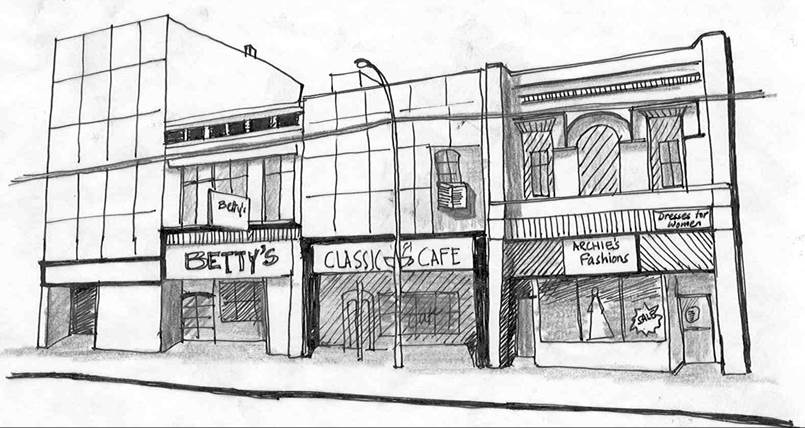
Examples of
inappropriate renovation include covering original facade with aluminum siding,
boarding up of windows, inappropriate signage etc.
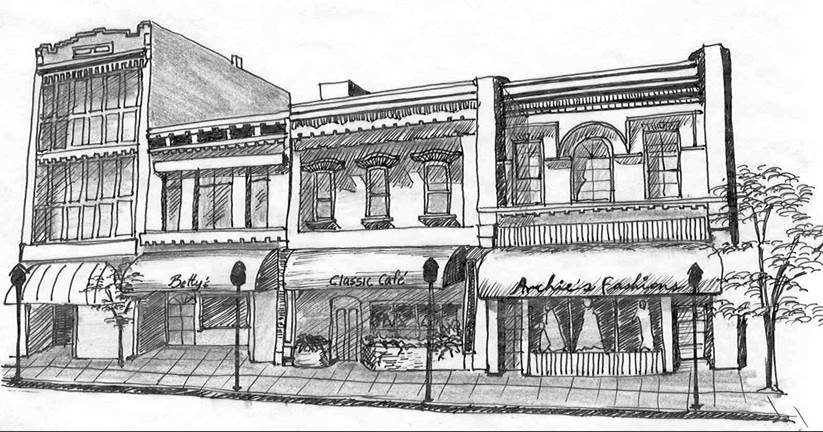
Restoration of
original facades with awnings and sensitive landscaping restore character to
the streetscape.
(Ord. 1020)
(1) General Description: The purpose of the Industrial District is to provide for the establishment of warehousing, manufacturing, and administrative office development. The overall character of the industrial district is intended to allow industrial development but to ensure that it is compatible with adjacent land uses, whether they be industrial, business or residential in nature. The method of ensuring such compatibility is by the imposition of performance standards which will lessen any potential detrimental effects of a particular industrial use.
(2) Uses Permitted: The manufacturing, compounding, assembly, packaging, repair, testing, treatment, wholesaling, or storage of products, materials or equipment, and physical recreation or training facilities (such as, but not limited to, dance studios and health clubs), and administrative office facilities, and sexually oriented businesses, and pawnshops, and facilities necessary to operate public services, are permitted uses in the I District.
(3) Uses Permitted Upon Review:
(a) Industrial Planned Overlay Districts as regulated in Sec. 16-310.
(b) Facilities necessary to operate public services.
(c) Adult Entertainment Establishments, provided that, no such use shall be in excess of twenty-five percent of annual gross receipts, or of inventory on hand at any time, or of its floor area at any time; and provided further, adult entertainment establishments shall comply with the following standards:
(I) The adult entertainment establishment must be properly and currently licensed pursuant to the provisions of city code.
(II) The adult entertainment establishment shall not be located within 750 feet of any premises currently licensed as such a use or within 750 feet of any licensed day care facility, private residence, house of worship, school, playground, park, library, or other community recreational center or facility, or any other sexually oriented business. Measurements shall be made in a straight line, without regard to intervening structures or objects, from the nearest point of the lot containing or to contain the sexually oriented business to the nearest point of the lot containing one of the uses mentioned.
(III) The adult entertainment establishment shall not be located in or on any building, premises, or lot already containing a sexually oriented business.
(4) Accessory Uses Permitted in the I District:
(a) Retail sales activities may be conducted within the I District under the following conditions:
(I) The retail sales activity is not located in an administrative office facility, but is located within a business, the principal use of which is not commercial sales.
(II) The retail sales activity does not occupy more than 15 percent of the gross floor area of the occupied portion of the premises.
(III) The retail sales activity is accessory to the principal use.
(IV) No sign identifying the retail sales activity is visible from the outside of the building.
(b) Outdoor storage, as regulated by this chapter, shall be permitted as accessory to the principal use on the lot.
(c) A dwelling unit for an on-site manager, caretaker, or security personnel which is attached to the principal building of a self-storage facility shall be permitted as accessory to the principal use on the lot. The dwelling unit shall be constructed in accordance with the Uniform Building Code and this chapter and shall have the same exterior materials as the principal building.
(d) Private antennas and towers in compliance with Section 11 of this article are permitted as an accessory use.
(e) All new construction not included in a Planned Overlay District shall require Site Plan Approval.
(5) Lot Requirements and Setbacks; Building Requirements; Standards for Specific Uses.
(a) General standards. All uses of whatever nature located in the Industrial District shall comply with the following standards, subject to additional requirements, exceptions and modifications set forth in this chapter. Development in this district shall not be allowed without public sewer and water.
(b) Minimum lot size and Setbacks. The standards expressed in Table 1 shall apply.
(c) Screening. Screening, as required in, shall be provided as follows:
(I) A buffer yard as described shall separate all lots from adjoining residentially zoned property sharing a common lot line.
(II) Outdoor storage must be screened from all lot lines.
(III) Parking lots shall be screened from residentially zoned properties.
(IV) Loading docks and garage entrances and exits shall be screened so as to minimize visibility from and from any residentially zoned property.
(d) Building exteriors. 30% of the facades of all buildings located in the I District shall consist of brick, stone, or glass, or any combination thereof, or an alternative decorative material approved by the Planning Commission, including, but not limited to, decorative masonry, but not including such things as metal or smooth-faced block.
(I) Exteriors of buildings in the I District for which a building permit had been issued as of the effective date of the ordinance from which this chapter is derived are exempt from this requirement, as are additions to any such buildings.
(II) The Planning Commission shall be responsible for reviewing building designs and exterior materials and for making recommendations regarding building designs and exterior materials with regard to all buildings governed by this subsection, and shall be responsible for reviewing and making recommendations concerning alternate exterior materials.
(e) Principal use to be conducted inside building. The principal use shall be conducted within a building.
(f) Parking facilities. All parking facilities shall conform with the standards established in Section 16-501.
(g) Loading facilities. Loading facilities shall meet the standards established in Section 16-501.
(h) Access. Lots in the I district shall receive access from the lowest classification street to which they are adjacent.
(i) Planned Overlay Districts. No parcel of less than ten acres in area shall be developed as an industrial POD, except that a parcel as small as five acres in area may be developed as an industrial POD if the sole access to the parcel is from an arterial street.
(j) Environmental standards. All of the performance standards contained in State regulations shall apply to all uses permitted in the I District. For any development located within 1,000 feet of residentially zoned property, the city may require a report, paid for and submitted by the applicant, from a city-approved testing firm, certifying that the proposed use will conform with environmental performance standards.
(1) General Description: The flood plain overlay districts consist of (FW) the Floodway and (FF) the Floodway Fringe.
(a) Floodway and Floodway Fringe district boundaries shall be the same as provided by the Federal Insurance Administration on the flood hazard boundary maps and in the flood insurance report. Actual ground location of Floodway and Floodway Fringe boundaries shall be located by the developer by field survey using the reference marks and vertical controls provided by the F.I.A. study.
(b) Where interpretation of floodway and floodway fringe boundaries are disputed, the codes administrator shall make the necessary interpretation. In cases where interpretation is contested, the board of zoning appeals, upon written application, shall resolve the dispute. The base flood elevation for the point in question shall be a governing factor in locating the district boundary on the land.
(2) Uses Permitted: New construction districts, if they meet the following elevation requirements:
(a) Residential structures shall be constructed with the lowest floor, including basement, elevated a minimum of two feet above the base flood elevation; and
(b) Non-residential structures shall be constructed or flood proofed to a minimum of one foot above the base flood elevation.
(1) Purpose.
This district is established to provide a comprehensive procedure and standards designed to allow certain developments which are consistent with the spirit and intent of the city’s comprehensive plan even though such developments fail to meet all of the dimensional requirements of other sections of this chapter. A Planned Overlay District (POD) is intended to allow variation from the strict literal provisions of this chapter, including, but not limited to, requirements relating to setbacks, height, floor area, dwelling type, floor area ratio, lot area, width, depth, and yards. If a proposed development is approved by the city as a POD as provided in this section, then the dimensions of the POD as approved shall be deemed to be in compliance with all of the dimensional requirements of this chapter, including setbacks, height, floor area, floor area ratio, lot area, lot width, lot depth, and yards.
A POD shall be voluntary or imposed by the City. A POD may be residential, business, industrial or mixed use in nature. A residential POD may allow all uses permitted in all the residential zoning districts and must be developed as a Use Permitted Upon Review within residentially zoned property. Developments with more than one type of dwelling must be developed as a POD. A commercial POD may allow all uses permitted in the C and CD zoning districts and must be developed as a Use Permitted Upon Review within property zoned C. An industrial POD may allow all uses permitted in the I zoning district and must be developed as a Use Permitted Upon Review within property zoned for industrial uses.
A POD is intended to result in a development in which the living or working environment is better than could otherwise have been achieved through strict enforcement of the dimensional requirements of other applicable sections of this chapter. A POD will not be permitted unless the landowner demonstrates that the development would be consistent with the spirit and intent of the city’s comprehensive plan, that the development would be consistent with the spirit and intent of this chapter, and that the development would tend to accomplish the following objectives for PODs:
(a) For any POD with a residential component, innovations to include within a single development a greater variety in type, design, and siting of dwellings to meet the growing demands for housing at various economic levels;
(b) Higher standards of site and building design through the use of trained and experienced land planners, architects, and landscape architects;
(c) The preservation and enhancement of desirable site characteristics such as natural topography and geographic features, and the protection of natural vegetation and water features;
(d) An efficient use of land resulting in smaller networks of utilities and streets, hereby lowering housing costs and public investments;
(e) A development pattern in harmony with the objectives of the city’s comprehensive plan; and
(f) A more desirable environment than would be possible through the strict application of the zoning and subdivision regulations of the city.
(2) Planned Overlay District – Use of District and District Notations:
(a) The Planned Overlay District must always be used in conjunction with one of the other zoning districts, known as the underlying district. The requirements of the Planned Overlay District shall be in addition to the requirements of the underlying district, and the Planned Overlay District may modify one or more of the regulations of the underlying district pursuant to the procedures set forth in this section.
(b) A Planned Overlay District shall correspond to the underlying district based on the following notation:
(3)
|
District |
Planned District Equivalent |
|
RS (Residential
Single-Family) |
RSPOD (Planned
Residential Single-Family) |
|
RT(Residential
Two-Family) |
RTPOD (Planned Residential
Two-Family) |
|
RM (Residential
Multi-Family) |
RMPOD (Planned
Residential Multi-Family) |
|
C (Commercial) |
CPOD (Planned Commercial) |
|
I (Industrial) |
IPOD (Planned Industrial) |
(4) Planned Overlay District – Relationship to Subdivision Regulations:
(a) Except as otherwise provided, the use of the Planned Overlay District shall be separate from the subdivision regulations of the city and the development plans required by the Planned Overlay District shall not be construed as plats.
(b) Subdivision approval shall follow zoning district amendment and/or preliminary plan approval.
(5) Preliminary Development Plan – Application Contents and Submission Requirements:
(a) Application: An application shall include the following:
(I) An affidavit of ownership:
(i) If an application is filed by a landowner, an affidavit of ownership shall be submitted with the preliminary development plan.
(ii) If an application is filed by an agent of a landowner, an affidavit of the landowner establishing the agent’s authorization to act on behalf of the landowner shall also be submitted with the preliminary development plan.
(iii) The affidavits required by this section shall be on forms provided by the city or in such form as is acceptable to the city and shall be submitted at the time of filing the application.
(II) A document containing the name, address and telephone number of all persons preparing any technical studies, maps, drawings, and documents submitted with the preliminary development plan.
(III) An accurate legal description of the property for which the application is submitted.
(IV) Any technical studies that may be required by the city. Examples of technical studies that may be required shall include, but not be limited to, traffic studies, engineering studies, geologic or hydrogeologic studies, flood studies, environmental impact assessments, noise studies, or surface water management/drainage studies. Notwithstanding the fact that the consulting city engineer did not require submission of a technical study in support of an application, either the Planning Commission or the governing body may require the submission of a technical study prior to taking action on the application.
(V) A statement regarding adequate public facilities and services for the proposed development. With a preliminary development plan the applicant shall submit proof of having reviewed the development proposal with applicable officials regarding public services and facilities not supplied by the city, including electric utility, school, highway, and street and road officials. Proof of this review shall be provided in a manner approved by the consulting city engineer. These forms shall provide an opportunity for applicable water, storm and waste water, fire, gas, electric, school and highway and street and road officials to provide comments on the existing and future availability and timing of services and facilities provided by their respective districts, agencies, or departments to the subject property.
(VI) A small key map with north arrow indicating the location of the property within the city, at a scale of one inch equals 1,000 feet or more.
(b) Required Submittals:
The following maps shall be submitted with the preliminary development plan application:
(I) One or more maps (at a scale of one inch equals 100 feet or less) of the proposed development that includes the following:
(i) Existing and proposed grades or contours for the entire site at two-foot contour intervals taken from the city’s aerial topographic maps or from an actual field survey;
(ii) Proposed location of different land uses;
(iii) Any land areas within the 100-year floodplain or a statement that no part of the site is within the floodplain.
(iv) General location of public streets, identifying arterials, and collectors and points of access to existing public rights-of-way;
(v) Existing and proposed water, sewer, and storm utility systems, including connections points to the existing systems;
(vi) Existing streams and other bodies of water;
(vii) Views within the site;
(viii) Vistas to and from the site;
(ix) Focal points and site amenities;
(x) Internal and external pedestrian and vehicular access points;
(xi) Physical barriers (including controlled access highways);
(xii) Proposed noise generation sources; and
(xiii) An analysis of the demand for water service and discharge into the sanitary sewer receiving system.
(xiv) One or more maps of the area within 200 feet of the subject property that contains the following:
1. Any public streets;
2. Street and traffic patterns affecting the site;
3. Any drives that exist or that are proposed to the degree that they appear on plans on file with the city;
4. Any buildings that exist or are proposed to the degree that their location and size are shown on plans on file with the city. Single and two-family residential buildings may be shown in approximate location and general size and shape;
5. The location and size of retention basins, detention basins and drainage structures, such as culverts, paved or earthen ditches or storm water sewers and inlets; and
6. Surrounding uses and adjacent properties.
(ii) Each map submitted shall contain the following information:
1. Date of preparation, including the date of the most recent revision;
2. Name, address and telephone number of the person who prepared, or person responsible for preparing, the map;
3. Scale;
4. North arrow;
5. Location of property lines of the subject property, and any section or quarter section lines and benchmarks used for elevations shown in the plan; and
6. Existing land uses, structures, and public and private streets.
7. The preliminary development plan shall be stamped by the engineer preparing the plan.
(6) Preliminary Development Plan – Consideration:
(a) Planning Commission Hearing. The Planning Commission shall hold a hearing to consider the preliminary development plan application. The recommendation of the Planning Commission on the preliminary development plan shall be forwarded to the governing body.
(b) Governing Body Hearing. Following review and recommendation by the Planning Commission, the governing body shall review the application. The governing body may then approve, conditionally approve, or disapprove the preliminary development plan application. As a condition of approval, the governing body may designate itself as the entity that shall review the final development plan.
(c) Criteria for Approval. The Planning Commission and governing body shall use the applicable zoning ordinance regulations as a guide for review of the preliminary development plan. If the governing body imposes conditions or restrictions on a preliminary development plan, it may designate specific requirements that must be met before an applicant may submit a final development plan application. In considering any preliminary development plan application, the Planning Commission and the governing body may give consideration to the criteria stated below, to the extent they are pertinent to the particular application. In addition, the Planning Commission and the governing body may consider other factors which may be relevant to a particular application.
(I) The character of the neighborhood;
(II) The zoning and the uses of nearby properties, and the extent to which the proposed use would be in harmony with such zoning and uses;
(III) The suitability of the property for the uses to which it has been restricted under the applicable zoning district regulations;
(IV) The length of time the property has remained vacant as zoned;
(V) The extent to which approval of the application would detrimentally affect nearby properties;
(VI) The extent to which the proposed use would substantially harm the value of nearby properties;
(VII) The extent to which the proposed use would adversely affect the capacity or safety of that portion of the road network influenced by the use, or present parking problems in the vicinity of the property;
(VIII) The extent to which utilities and services, including but not limited to, sewer, water service, police and fire protection, and parks and recreation facilities, are available and adequate to serve the proposed use;
(IX) The extent to which there is a need for the use in the community;
(X) The economic impact of the proposed use on the community;
(XI) The ability of the applicant to satisfy any requirements applicable to the specific use imposed pursuant to the zoning district regulations;
(XII) The gain, if any, to the public health, safety and welfare due to denial of the application as compared to the hardship imposed upon the landowner, if any, as a result of denial of the application;
(XIII) The conformance of the proposed use to the Comprehensive Plan and other adopted planning policies; and
(XIV) The recommendation of professional staff.
(d) Modification of Underlying District Regulations.
(I) Any plan proposing modification of any underlying district regulation shall be accompanied by a letter outlining the proposed modification(s) and the reason(s) therefore.
(II) The Planning Commission may recommend, and the governing body may approve, a preliminary development plan that modifies one or more of the restrictions or regulations found in the zoning ordinance, including, but not limited to, density and minimum lot size requirements, dwelling type, floor-to-area ratios, design standards, required minimum public improvements, building materials and color, maximum structural heights, parking, landscaping, buffering and tree protection requirements.
(III) A preliminary development plan that contains proposed modifications from one or more of the restrictions or requirements of the zoning ordinance, as authorized by this subsection, may be recommended for approval or approved, as the case may be, if the Planning Commission or governing body concludes that the development proposed by the preliminary development plan will provide sustainable value to the city, incorporates sound planning principles and design elements that are compatible with surrounding properties and consistent throughout the proposed project, effectively utilize the land upon which the development is proposed, and further the goals, spirit and intent of this chapter.
(IV) No separate vote on proposed modifications is required by this subsection. It is the intent of this subsection that the Planning Commission and the governing body evaluate the proposed preliminary development plan to determine if, as a whole, it is consistent with the approval criteria set forth herein and the purposes of this chapter.
|
Residential Density Bonus Calculations |
||
|
RM –
Residential Multifamily* |
10 15 20 or
greater |
1740
s.f. per dwelling unit 1575
s.f. per dwelling unit 1420
s.f. per dwelling unit |
|
RE –
Residential Elderly Housing** |
10 15 20 or
greater |
2175
s.f. per dwelling unit 1950
s.f. per dwelling unit 1740
s.f. per dwelling unit |
|
* One acre minimum site size continues to
apply for any planned development where the RM District is the underlying
district. |
||
|
** 7500 square feet minimum site size
continues to apply for any planned development where the RE District is the
underlying district. |
||
(7) Preliminary Development Plan - Duration: Approval of the preliminary development plan shall be valid for one year from the date of its approval. Upon request of the applicant and approval by the governing body, the duration of approval may be extended for a period of not more than one year. The filing and approval of a final development plan for any phase of the area contained in the preliminary development plan shall extend the period of validity by an additional two years.
(8) Revised Preliminary Development Plans:
(a) Requirement. Once a preliminary development plan has been approved, changes in the preliminary development plan may be made only after approval of a revised preliminary development plan.
(b) Procedure for revised preliminary development plan applications
(I) An applicant who has received approval of a preliminary development plan may request approval of a revised preliminary development plan at least 10 working days prior to the scheduled consideration of the final development plan.
(II) When an application for a revised preliminary development plan is filed, city staff representatives shall determine whether the revised preliminary development plan involves substantial changes, and shall notify the applicant of the nature of the requested changes and of the procedure that applies to consideration of the application for a revised preliminary development plan. The determination of the staff may be appealed to the Planning Commission, whose decision shall be final.
(c) Substantial Changes. Substantial changes, as defined in this section, to the approved preliminary development plan may be approved only by the governing body after review and recommendation by the Planning Commission. Approval of substantial changes to the approved preliminary development plan shall follow the procedure for original approval of the preliminary development plan.
(d) Minor Changes. Minor changes to the approved preliminary development plan, as defined in this section, may be approved by the Planning Commission. Minor changes may be approved by the Planning Commission without a public hearing.
(e) Limitation on Revised Development Plans. No more than two revised preliminary development plans may be approved that involve either minor changes, as defined in this subsection, or a reconfiguration of the building locations of the plan.
(f) Definition of Substantial Changes. For purposes of this section, “substantial changes” to the approved preliminary development plan shall mean any of the following:
(I) Changes in the density or intensity of residential uses greater than 5 percent.
(II) Increases in the total floor area of all nonresidential buildings covered by the plan greater than 10 percent.
(III) Increases of lot coverage greater than 5 percent.
(IV) Decreases of areas devoted to open space greater than 5 percent, or the substantial relocation of such areas.
(V) Changes of traffic circulation patterns that will affect traffic outside of the project boundaries.
(VI) Modification or removal of conditions to the preliminary development plan approval.
(VII) Changes to the water or sanitary sewer plans that impact these utilities outside the project boundaries.
(g) Definition of minor changes. For purposes of this section, “minor changes” to the approved preliminary development plan shall mean any of the following:
(I) Increases in the density of residential uses of less than 5%.
(II) Increases of lot coverage of less than 5%.
(III) Decreases of areas devoted to open space of less than 5%.
(h) Criteria for revised development plan. In determining whether to approve an application for a revised preliminary development plan, the Planning Commission or governing body shall apply the criteria set forth in this section. In the event that the application for the revised preliminary development plan is denied, the previously approved preliminary development plan will remain in effect.
(9) Final Development Plan - When Required. Approval of a final development plan is required any time a preliminary development plan is required. No building permit shall be issued until a final development plan is approved. A final development plan application may be combined with a preliminary development plan application.
(10) Final Development Plan – Application Contents and Submission Requirements:
(a) The number of copies of the final development plan, as required by the Codes Administrator, together with any applicable fees, shall be submitted when required. One digital copy of the final development plan shall also be submitted. If not submitted with the Preliminary Development Plan, no Final Development Plan may be submitted until the Preliminary Plan is approved by the City Council. If revisions to a Preliminary Development Plan are requested no Final Development Plan maybe submitted until the revisions are approved or denied.
(b) The final development plan shall be accompanied by the following supporting documents or materials:
(I) A document containing the name, address and telephone number of all persons preparing any technical studies, maps, drawings and documents submitted with the final development plan;
(II) An accurate legal description of the property for which the application is submitted;
(III) Any technical studies that may be required by the city;
(IV) A statement documenting the provision of adequate public services and facilities. At the time of submittal of a final development plan, the applicant shall submit to the consulting city engineer documentation of whether adequate public services and facilities are, or will be, available to serve the proposed development, including adequate water, sewer, fire, gas, electric, school services and highway and street and road facilities. If adequate public facilities and services are not presently available at the time of submittal of these applications, or are not planned to be available reasonably concurrent with the anticipated impacts of the proposed development, as determined by the affected utility company, agency or department, the application may be denied;
(V) A small key map with north arrow indicating the location of the property within the city, at a scale of one inch equals 1,000 or larger;
(VI) Deeds of dedication for all rights-of-way or easements required as a result of preliminary development plan approval, if conveyance thereof is not to be made by plat;
(VII) A copy of all covenants and restrictions applicable to the development, if required by the terms of the preliminary development plan;
(VIII) A storm drainage management system that complies with the City's adopted design requirements (provided that any such storm drainage management system shall be subject to approval by the consulting city engineer);
(IX) Evidence of the establishment of the agency for the ownership and maintenance of any common open space and all assurances of the financial and administrative ability of such agency, if required by the terms of the approved preliminary development plan; and
(X) Evidence of satisfaction of any conditions of the preliminary development plan approval that were conditions precedent to consideration of the final development plan.
(c) The final development plan shall consist of one or more maps that show the following:
(I) All proposed and existing adjacent public street rights-of-way with centerline location and right-of-way widths;
(II) All proposed and existing public street and public drive locations, widths, curb cuts and radii;
(III) Location, width and limits of all existing and proposed easements;
(IV) Location, width and limits of all existing and proposed sidewalks;
(V) Location, size and radii of all existing and proposed median breaks and turning lanes;
(VI) Distance between all buildings, between buildings and property lines and between all parking areas and property lines;
(VII) Location of all required building and parking setbacks;
(VIII) Location, dimensions, number of stories and area in square feet of all proposed buildings;
(IX) Area of land on plan in square feet or acres;
(X) The location of all oil and/or gas wells on the property;
(XI) Limits, location, size and material to be used in all proposed retaining walls;
(XII) Location and dimensions of all driveways, parking lots, parking stalls, aisles, loading and service areas and docks;
(XIII) Location, height, intensity and type of outside lighting fixtures for buildings and parking lots;
(XIV) Location, size, and type of material of all proposed monument or freestanding signs;
(XV) The location of adjacent developments, alignment and location of public and private driveways and streets, medians, and public and semi-public easements;
(XVI) Final storm water collection, detention and erosion control plans;
(XVII) Final analysis of the capacity of the existing sanitary sewer receiving system; and
(XVIII) Final water and sanitary sewer plans.
(d) Each map submitted shall contain the following information:
(I) Date of preparation, including the date of the most recent revision;
(II) Name, address and telephone number of the person who prepared, or person responsible for preparing, the map;
(III) Scale;
(IV) North arrow;
(V) Location of property lines of the subject property, and any section or quarter section lines and benchmarks used for elevations shown on the plan;
(VI) Finished grades or contours for the entire site at two-foot contour intervals taken from the city's aerial topographic maps or from an actual field survey; and
(VII) Existing land uses, structures and public and private streets.
(e) One or more illustrations shall be submitted with the final development plan showing building elevations including the following:
(I) Elevations of all sides of proposed buildings except for single and two-family residential buildings including notation indicating building materials to be used on exteriors and roofs;
(II) Size, location, color and materials of all signs to be attached to building exteriors;
(III) Location, size and materials to be used in all screening of rooftop mechanical equipment; and
(IV) Building sections.
(f) One or more illustrations shall be submitted with the final development plan showing dimensions and areas of all floors within proposed buildings for which building elevations are required.
(g) One or more illustrations shall be submitted with the final development plan showing landscaping and tree preservation.
(h) One copy of the proposed plan, building elevations, landscaping and tree preservation plan shall be reduced onto 8 1/4-inch by 11-inch bond paper.
(i) A final development plan application may also constitute and be considered to be a preliminary plat application provided said application complies with all applicable requirements of the Subdivision Regulations. If the applicant wishes to have the final development plan application also considered as a preliminary plat application, a written request therefore shall be submitted at the time of filing the application.
(j) The final development plan shall be stamped by the engineer preparing the plan
(11) Preliminary and Final Plat. The applicant may submit a Preliminary Plat for all of the development and a Final Plat for however much of the development is desired. Such plats must conform with the requirements of the subdivision ordinance and contain all of the information required therein for such plats.
(12) Final Development Plan – Consideration:
(a) The final development plan must be acted upon by the Planning Commission.
(b) Governing Body Approval. A final development plan shall be submitted for approval by the governing body only if approval of the preliminary development plan was conditioned upon the subsequent approval of a final development plan by the governing body, or in the case of an appeal of the Planning Commission determination. Following consideration of the final development plan, the governing body shall approve, approve with conditions, or disapprove the plan.
(c) Criteria for Approval. In determining whether to approve an application for a final development plan that contains changes from the preliminary plan, the Planning Commission or governing body shall apply the criteria set forth in these regulations applicable to a preliminary development plan application.
(d) Conditions on Approval. If the Planning Commission or the governing body attaches conditions to the approval of a final development plan, it shall designate specific requirements that must be met before issuance of a building permit. The governing body may delegate to the consulting city engineer the authority to determine whether the specifically prescribed conditions attached to the approval have been satisfied by the applicant. As a condition of approval, the applicant may be required to execute a development agreement that is satisfactory to both the applicant and the city.
(e) Approval of Preliminary Plat. In all cases where the applicant has requested that final development plan approval also constitute preliminary plat approval, the application shall be submitted for approval by the governing body following recommendation by the Planning Commission. The governing body may elect to approve the application as a final development plan, but not approve the application as a preliminary plat.
(13) Final Development Plan - Duration of Approval. Construction of a planned development, or the first phase of a planned development if phases are applicable, shall begin within one year from the date that final development plan approval is granted. One extension for no longer than one year may be granted by the governing body. If construction does not begin within one year or such period for which an extension has been approved, the final development plan shall expire and be voided.
(14) Planned Development Standards. The following development standards shall apply to all development that occurs in a Planned Overlay District.
(a) Allowed Uses. In any Residential Overlay District, unless otherwise restricted, any use permitted in residential zone shall be permitted. The uses permitted in a Commercial Planned Overlay District are those uses permitted in the C District. Industrial Planned Overlay Districts may contain any use permitted in the I District. Uses may be voluntarily restricted by the applicant, or restricted as a condition of approval of the preliminary or final development plan by the Planning Commission or governing body.
(b) Preservation of Natural Features. Mature trees, vegetative cover, watercourses and other natural site features shall be preserved to the greatest extent possible. Abrupt changes in natural slope shall be avoided. Preservation shall be directed toward:
(I) enhancing the quality of new development,
(II) protecting the natural environment, and
(III) preserving the character of existing neighborhoods.
(c) Common Open Space Ownership. Such uses shall be dedicated to the public in subdivision tracts and easements, unless otherwise stipulated by the city council; and the subdivider shall attached to the plat affidavits of agreement to not petition against special assessment benefit districts for funding of maintenance services associated with the dedicated open space.
(d) Common Open Space Standards. A minimum of three percent of the gross area of every planned development containing 10 or more dwelling units shall be devoted to common open space for the use and enjoyment of the residents.
(I) The following areas qualify wholly or partially as common open space:
(i) Major Recreation Areas. The total area of an improved recreation area may be counted as common open space. An improved recreation area shall be at least 20,000 square feet in size and shall be linked to all dwelling units within the planned development by a continuous pedestrian circulation system of sidewalks or trails. A golf course may be used to satisfy a maximum of 50 percent of the common open space requirement.
(ii) Mini-Parks. The total area contained in mini-parks that have a minimum dimension of 10,000 square feet and that include benches, playground apparatus, barbecue pits, fire rings or other approved recreational amenities may be counted as common open space.
(iii) Recreational Buildings. The area occupied by a multiple-use recreation building and its attendant outdoor recreation facilities, excluding a golf course, may be counted as common open space.
(iv) Pedestrian Open Space System. The total area contained in a continuous open space pedestrian system, not less than 10 feet wide, consisting of permanently maintained walks and trails leading to a natural amenity, recreation facility, park or commercial use and offering circulation that is separate from roads and streets and sidewalks adjacent to roads and streets may be counted as common open space.
(v) Environmental Features. If natural habitats of significant value or environmentally sensitive areas are determined to exist, the governing body may require the area so defined to be left in an undisturbed state or incorporated into the design of the planned development as a passive recreation area with a minimum of improvements. In either case, the total area contained therein may be counted as common open space.
(vi) Detention Areas. Open areas adjacent to detention facilities which are above the 100-year flood elevation and have a slope of 6:1 or flatter may be counted as common open space. Areas below the 100-year flood elevation may be used to satisfy up to 50% of the common open space requirement if the side slopes do not exceed 6:1, the total depth of the detention area is five feet or less, a trickle channel is provided and the bottom is graded to drain without ponding.
(e) Maintenance of Common Open Space. Any common open space established by a final development plan shall be subject to the following requirements:
(I) Responsibility. If not dedicated to the public and improved by a private association, an organization for ownership and maintenance of common open space shall be established and approved by the city as a condition of plat approval, which condition shall assure that such organization shall not be dissolved. Further, such organization shall not dispose of any private common open space, by sale or otherwise (except to an organization conceived and established to own and maintain the common open space), without first offering to dedicate the common open space to the city. The conditions of any transfer shall conform to the final development plan.
(II) Failure to Maintain. In the event that the organization established to own and maintain private common open space shall fail to maintain the common open space in a reasonable condition, the codes administrator shall serve written notice upon such organization, setting forth the maintenance deficiencies. The failure to correct such deficiencies within 30 days shall be deemed a violation of this zoning ordinance, subject to penalty and enforcement provisions.
(f) Phased Developments. At the time of preliminary development plan approval, the applicant may propose, or the city may require, that a phasing plan be submitted that sets forth the timing and sequencing of development among various types of uses or subgroups of uses or structures in the development.
(15) Vested Rights in a Planned Overlay District:
(a) For the purpose of single-family residential developments in a planned overlay district, development rights in such land use shall vest upon recording of a plat of such land. If construction is not commenced on such land within five years of recording a plat, the development rights in such shall expire.
(b) For all purposes other than single-family developments, the right to use land in a planned overlay district for a particular purpose shall vest upon the issuance of all permits required for such use and construction has begun and substantial amounts of work have been completed under a validly issued permit.
(1) General Description: The purpose of this district is to promote the image that quality development occurs along the K-10 roadway. This is achieved by coordinating public enhancement with private development efforts, by guiding orderly, highly aesthetic development along the corridor and by establishing a uniform process for evaluating each development for compatibility. To this end, the district proposes design guidelines and design requirements with the following purposes:
(a) To guide both public and private development along the corridor.
(b) To enhance property values along the corridor.
(c) To create order among developments through enhancement of the landscape along the corridor.
(d) To develop a quality visual experience consistent with natural character of the existing corridor.
(e) To preserve and enhance the natural environment.
(f) To ensure positive visual quality and provide a memorable visual experience to users of the corridor.
(g) To coordinate intergovernmental influence along the corridor.
(2) Use of the K-10 District: The Kansas Highway 10 Overlay District must always be used in conjunction with one of the other zoning districts, known as the underlying district. The requirements of the K-10 District shall be in addition to the requirements of the underlying district, except that the K-10 District may modify some of the regulations of the underlying district in specific situations. A K-10 District may be used in conjunction with any of the other zoning districts or with any combination of districts.
(3) Uses Permitted: Any use permitted in the underlying zone shall be permitted. The uses permitted may be voluntarily restricted to the applicant, or restricted as a condition of approval by the Planning Commission.
(4) Uses Permitted Upon Review: Any use permitted upon review in the underlying zone shall be permitted. The uses permitted upon review may be voluntarily restricted by the applicant, or restricted as a condition of approval by the Planning Commission.
(5) Area Requirements:
(a) Lot Area, Lot Width, and Lot Depth: The lot area, lot width, and lot depth requirements provided for in the underlying zoning district shall be required.
(b) Yard Requirements: The yard regulations provided for in the underlying zoning district shall be required. Provided, however, the yard regulations must meet the following minimum standards with additional distance provided for actual building locations depending on the size and scale of the building:
(I) Setback Standards:
(i) Residential or industrial building: 75 feet from K-10 Highway, right-of-way.
(ii) Commercial building: 75 feet from the K-10 highway right-of-way with the building front facing K-10;
(iii) Parking setback standards will be 25 feet from the K-10 Highway right-of-way.
(II) Side Yards:
(i) 25 feet for all non-residential land uses.
(6) Additional Design Guidelines: The following additional design guidelines shall apply to all structures constructed within the K-10 District:
(a) Architecture:
(I) Blank walls without doors and windows should not face the Kansas Highway 10 roadway.
(II) Mirrored and/or reflective glass on buildings will be designed to minimize glare onto the Kansas Highway 10 roadway.
(III) Painted advertising on structures is not permitted.
(IV) Signs on buildings are limited to company name or logo and address.
(V) Secondary structures will be architecturally compatible with the main structure.
(VI) Masonry (brick, stone, and stucco) is encouraged for detailing on buildings.
(VII) Additions to existing buildings will adhere to the setback standards contained in the district but additions that correct existing deficiencies to the setback standards will be allowed.
(b) Signage:
(I) One square foot of sign face per five linear feet of frontage on the Kansas Highway 10 roadway, up to a maximum of 75 square feet for business sites up to five acres; in larger projects or projects with multiple tenants, a larger sign consistent with the architectural scheme of the business park may be permitted.
(II) Free standing pole mounted signs are not permitted on properties abutting the Kansas Highway 10 roadway.
(III) Flashing, moving, portable, or animated signs are not permitted in the district.
(IV) Billboards are not permitted by these district standards or by the City Sign Code.
(V) Gas signs may include gas grade advertising showing only three grades of gas on a maximum of 30 percent of sign face square footage.
(VI) Signs are limited to maximum of three colors and two letter styles.
(VII) No signs are allowed on top of buildings.
(VIII) There is a maximum of one sign facing the Kansas Highway 10 roadway.
(IX) Temporary real estate signs are permitted within the K-10 District and can show phone numbers and lot information.
(c) Existing Vegetation:
(I) 12” caliper trees and above may not be removed from the land, except to locate the proposed building.
(II) For every 10” caliper and larger tree removed, one replacement tree is required.
(d) Lighting:
(I) Lights should be non-glare, cut off fixtures with metal halide bulbs or other energy efficient lights.
(II) Light standards and fixtures in parking lots should be a maximum of 30 feet in height meeting a standard of 0.8 foot candles.
(III) Light sources should not be visible from the Kansas Highway 10 roadway.
(e) Planting:
(I) The following planting requirements, for each 50' of setback from the Kansas Highway 10 right-of-way and for each 100' of lot frontage onto the Kansas Highway 10 corridor shall apply:
(i) Two shade trees with a minimum 2.5” caliper.
(ii) Two ornamental trees with minimum 2” caliper.
(iii) Four evergreen trees with a minimum 8' height.
(f) Parking:
(I) Bicycle parking will be provided in relationship with the entry to the building.
(II) Interior landscape islands will have a 10 foot minimum width and equal a minimum of eight percent of the total parking area.
(III) Interior landscape islands will be landscaped with shade trees, ornamental trees and low shrubs at appropriate locations.
(IV) Parking areas shall be screened from the view of both the Kansas Highway 10 roadway and also any adjacent unrelated land uses. Such berming and vegetation shall have a 42” minimum height on land, where there is little variance in elevation from the Kansas Highway 10 roadway and adjacent uses. Where there is a change in elevation on such land making a berm impractical, increased landscaping shall be used.
(g) Roads:
(I) Reverse frontage roads (which locates the frontage road to the rear of the properties adjacent to Kansas Highway 10) will be encouraged.
(h) General Requirements:
(I) Each lot shall have a minimum 20 percent landscape/open space area, exclusive of parking areas.
(II) Non-agricultural fencing may only be decorative in type.
(III) Loading docks, mechanical equipment, solar panels, waste storage, and product storage areas will not be located on the side of the building facing the Kansas Highway 10 roadway. If such equipment is located on the side visible from the Kansas Highway 10 roadway I it will be entirely screened from view with walls that are consistent with the building's architecture or evergreen vegetation.
(IV) Satellite dishes will adhere to the building setback requirements and will be screened entirely from view with evergreen vegetation.
(V) If the proposed use involves product display, no elevated or tilted areas are allowed.
(VI) Plans for development will identify existing or proposed facilities on adjoining property.